© Donal G. Burke 2013
The Muinnter Chobhthaigh or O Coffeys of east Galway origin are an offshoot of the wider Uí Maine family group, whose ancestor has traditionally been held to be one Maine mór, son of Eochaidh feardaghiall, chief of a tribe of people who established themselves as the dominant group in the eastern region of Connacht by about the end of the fifth century.[i] As such the family is distinct and separate from others bearing the same name established elsewhere in Ireland.
Maine mór and his descendants appear to have subjugated many of the existing tribes and peoples that inhabited their new land and established a petty kingdom, covering much of the later east Galway named from their progenitor as Uí Maine (later Anglicised Hy Many). The senior-most family descended from this Maine was the O Kellys, from whom the rulers or chieftains of Uí Maine were drawn.
Within the greater Uí Maine kin group the O Coffeys were part of the group of families who composed the Síol Anmchadha, the ‘seed’ or progeny of Anmchadh.’[ii] Descended from Anmchadh, son of Eoghan buac, son of Cormac, son of Cairbre Crom, this last, from whom most of the senior families of the Uí Maine claim descent, reputed to have flourished about the early or mid sixth century A.D. and to have been a fifth generation descendant of Maine mór.[iii]
The principal family of this family group, the O Maddens, came to rule a part of the eastern region of Uí Maine, to be known thereafter from their common ancestor as Síl Anmchadha or ‘O Maddens County’ and later as the barony of Longford in east Galway. Like the O Maddens, the Muinnter Chobhthaigh were said to be descended from Donngalach, the eldest son of Anmchadh.[iv] While the O Maddens would appear to have been of more senior descent in that line, the Muinnter Chobhthaigh share a close connection with another family descended from Donngalach, the Uí Donngalaigh or O Donnellys, a family distinct from the O Donnellys of northern Irish origin.
Given the original meaning of the name ‘Muinnter Chobhthaigh’ as the ‘people of Cobhthach,’ it would appear that the O Coffeys, within that family group, came from one bearing the Gaelic personal name Cobhthach, a descendant of Donngalach son of Anmchadh.
Not all families descended from Anmchadh would be found based within the confines of O Madden’s territory of Síl Anmchadha (or as it would later be known, the barony of Longford, in east Galway.) The O Coffeys were established within the wider territory of Uí Maine but immediately outside the territory of the O Maddens. They maintained a minor presence in the area about the parish of Clontuskert with their ancestral lands appearing to have been contained in the townland of Tuomcatry (later known as the townland of Kellysgrove) in that parish.
Part of the parish of Clontuskert lay within O Maddens country and part, to the west, within the territory of the O Kellys of Uí Maine or Hy Many. Tuomcatry lay immediately outside of the O Madden territory and, as such, their lands lay in the late medieval period within the immediate territory of a sub-branch or sept of the O Kellys whose wider lands comprised for the most part the later half barony of Clonmacnowen, named for their ancestor Owen or Eoghan.
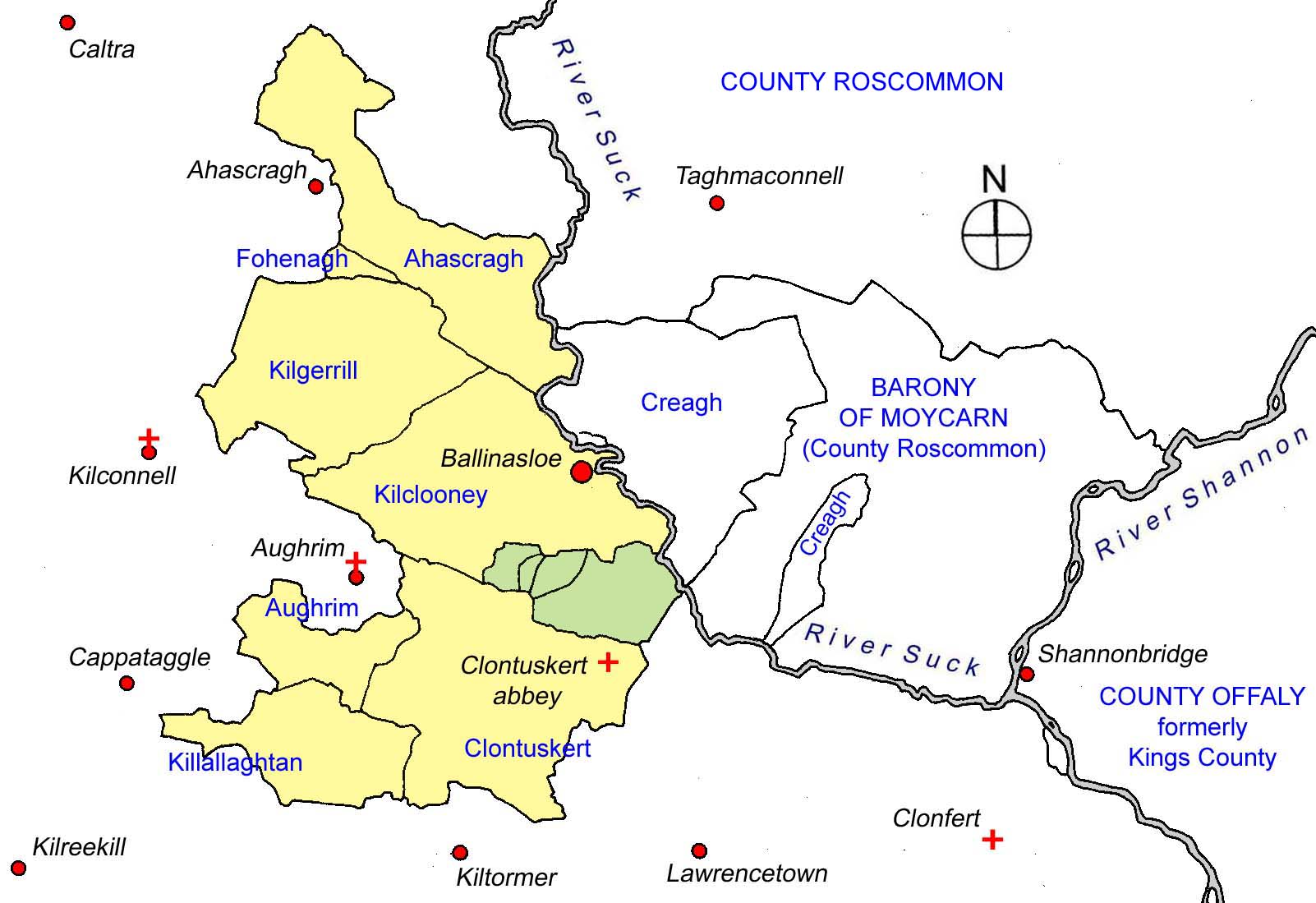
Map of the half barony of Clonmacnowen (in yellow) showing the townlands wherein members of the Coffey family held lands in the early seventeenth century (in green) in the parish of Clontuskert in relation to ecclesiastical centres and modern towns and villages (in red).
Situated immediately north of the later abbey of Clontuskert and south of the much later town of Ballinasloe, Tuomcatry was originally known as Tuam Chathraighe, and derived its name from the presence in ancient times of an early tribe of people who inhabited this area about the later parishes of Kilclooney and Creagh, straddling the River Suck, about the time of the rise of the Uí Maine, who subjugated them.[v] The tribe were known as the Catrigii or ‘the Cathraighe of the Suck’ and appear to have been allowed to remain within their original location for a time by the descendants of Maine mór. They were described in an account of the relationship of the tribes of that region to the O Kelly over-chieftain as one of ‘the enslaved tribes of Hy-Many for servitude,’ their territory extending from ‘Upper Tuaim Cathraighe to Porta Fidigi on both sides of the Suck.’[vi] The historian Fr. P.K. Egan identified ‘Upper Tuaim Cathraighe’ as a ‘portion of an area in Kilclooney parish extending over the townlands of Poolboy and Kellysgrove, astride the present boundary of Clontuskert and represented by the seventeenth century denominations, now obsolete, of Tomoughter, Tomeeter and Tomcatry.’[vii]
The ‘tuam’ in the denomination of Tuomcatry, an old Gaelic word for a ‘tumulus,’ rendered the translation of Tuomcatry as ‘the tumulus of the Catraighe.’[viii] The townland itself comprises of a rise of ground composed for the most part of gravel, atop which stood at one time a sharply raised mound. Nearby, along the same height, was located a children’s burial ground, identified as a ‘cillin.’ A large area of the surrounding land in the townland fell away to the east and northeast across boggy land towards the River Suck, rendering much of the denomination unprofitable. A large area of meadow near the river in the mid seventeenth century was recorded in the mid seventeenth century as being flooded throughout the winter.[ix]
Tuomcatry or ‘half a towneland in Tuam Catrighe’ was one of several denominations across east Galway said to have been bestowed upon the monastic settlement of Clonmacnoise by Cairbre crom, the senior sixth century chieftain of the Uí Maine.[x] The Church appears to have had some continued landed interest in Tuomcatry and it was apparently marked ‘Church Land’ in the seventeenth century Books of Survey and Distribution, at which time, prior to 1637, the occupier would be Edward son of the Protestant Dean of Clonfert, Kyvas Tully.[xi]
Loughlin O Kelly, who appears to have flourished about the latter half of the fourteenth century, a younger son of Donnchadh O Kelly, Chief of Uí Maine, made known to the Bishop of Clonmacnoise an earlier grant of lands to Clonmacnoise from another of his wider family which had been concealed or let lapse from some time.[xii] In return the Bishop of Clonmacnoise gave to Loughlin and his heirs six quarters of land for a fixed rent of livestock and on condition that they repair an old timber causeway across bogland on the west bank of the Shannon not distant from Clonmacnoise known as the Tóchar of Cloonburren. The six quarters of land given by the Bishop to Loughlin and his heirs all appear to have been in the area about Clontuskert and Kilclooney and included Tuomcatry.[xiii]
This Loughlin was descended from Eoghan finn, son of Donal mor O Kelly, chief of Uí Maine and from this Eoghan originated a wide family group of O Kellys known as the Clann Maicne Eoghain or ‘family of the sons of Owen.’ Their territory covered much of the area of Uí Maine that would later be known as the half-barony of Moycarn on the east bank of the Suck and the half-barony of Clonmacnowen on the west, centred about the later town of Ballinasloe and included the area about Clontuskert. Loughlin was ancestor of a minor sept of the O Kellys of the Clann Maicne Eoghain, who came to be known as the Sliocht Lochlainn or ‘descendants of Loughlin.’ In addition to the land that they were reputed to have held from the Bishop of Clonmacnoise at Tuomcatry and elsewhere about Clontuskert, they also held a small area of land, the quarter of Beagh in the parish of Creagh on the east bank of the Suck. As one of the sub-branches of the wider Clann Maicne Eoghain they owed tribute, rents and services to the more senior chieftain of Clonmacnowen within Uí Maine, who in the late sixteenth century was Sean na maighe O Kelly.[xiv] By the early seventeenth century the Sliocht Lochlainn only appear to have held lands in Beagh but continued there into the late nineteenth century.[xv]
At a certain stage prior to the late medieval period the O Coffeys were established on these lands at Tuomcatry and in an Inquisition taken into land ownership in August of 1617, one Donell O Coffey was found to have been in possession of four cartrons of land in Tuomcatry.[xvi] By 1618 or 1619 the greater share of the quarter of Tuomcatry, comprising three cartrons, was held by one Donogh O Coffey of Tuomcatry, gentlemen, while the smaller share, one cartron, was held by Donell O Coffey of Tuomcatry, gentleman.[xvii] The only other individual of the name holding lands in the region was given as Daniel Coffey of Graygenvonin, who held a small share, one half of a cartron of the nearby townland of Mackney.[xviii] (This ‘Graygenvonin’ is the townland of Graigueawoneen, in Clontuskert parish, adjacent to Kellysgrove and to Mackney.) As no other landholders of the name were given at this time, it would suggest that those of Tuomcatry were the senior-most members of the name, with Donogh possibly being the more senior.
Tuomcatry itself was regarded at that time as small in size, as a section of meadow called Srahalla, was held by the major landholder Thomas O Kelly of Clontuskert but described as a ‘parcel of the small quarter of Tuomcatry.’[xix]
In the late 1630s or about 1641, Tuomcatry, given as ‘Tuam Cattrin,’ was described as comprising two quarters of land in total. Donagh Coffy held the slightly larger portion of three cartrons and three fourths of a cartron, while one John Coffy held the lesser portion of three cartrons and a fourth part of a cartron. The remaining cartron was held by John Kelly.[xx] Daniel O Coffy still held a half cartron of the quarter of Mackney.
The O Coffeys lost possession of their lands in this area as a result of the Cromwellian confiscations and transplantations in the mid seventeenth century. Following the turmoil of that period and the restoration of the monarchy in the person of King Charles II in 1660, an Act of Settlement was passed in Parliament, in an attempt to address the complaints of those whose lands had been taken or divided by the Cromwellians and to placate those who had acquired lands at that time. Under the Act of Settlement all of the townland of Tuomcatry was confirmed in the possession of James Keally.[xxi] The Keally family were transplanted from County Kilkenny to the area about Tuam Chatriaghe by the Cromwellians and over time adopted the more locally-familiar name Kelly. The senior-most member of the transplanted family in the late seventeenth century was given as resident at ‘Tomcarty’ and from this newly-arrived family Tuam Chatriaghe would be known from at least the eighteenth century and thereafter as the townland of Kellysgrove.
Two of the family had their lands confiscated in whole or in part and were allocated lands elsewhere within the barony of Clonmacnowen. Daniel oge ‘the young’ Coffy of ‘Tumcattry’ was allocated a small section of land in the parish of Kilcooney.[xxii] His allocation was given in one record as forty-one profitable Irish acres and in another as six, while one Daniel Coffye of ‘Graigmonine’ (recte: Graigueawoneen) was allocated a smaller section of land in that parish, either nineteen profitable Irish acres or four. One Daniel Coffee, under the same Act of Settlement, was confirmed in possession of six profitable Irish acres in the nearby townland of Tomoghter, in the parish of Kilclooney.[xxiii] Another, one Thomas Coffee was possessor under the Act of seventy-seven profitable Irish acres in the townland of Callcagh, much further to the north in County Galway, in the parish of Kilcroan in the half barony of Ballymoe.[xxiv] A Daniel Coffey under the Act was confirmed in possession of seventy-nine acres of land in the townland of Ballinlough, parish of Kiltullogh, in the barony of Ballintubber in County Roscommon, lands formerly those of a member of the O Flynn family. It is unclear, however, if this Daniel is connected with the family of Tuomcatry.[xxv] Coffeys continued to reside about Tuomcatry after the Acts of Settlement, with a headstone surviving at the ruins of Clontuskert friary bearing the inscription ‘John Cofy late of Tumcatry Ano Dome 1720′.
In 1752 Daniel Coffey of Aghrim, County Galway, alongside Margeret Coffey of the same address, conformed to Protestantism. It is possible that this Daniel and Margaret Coffey may have been connected with, or related to, one Susanna Coffey who married in 1745 George Evans Crowe of Aughrim, County Galway, Esquire, son of the Very Revd. William Crowe, Protestant Dean of Clonfert and was mother to three children; Richard Thomas, Elizabeth and Emily Crowe.[xxvi]
[i] Knox, H.T., The Early Tribes of Connaught: part 1, J.R.S.A.I., Fifth series, Vol. 10, No. 4, 1900, p. 349; Mannion, J., The Senchineoil and the Sogain: Differentiating between the Pre-Celtic and early Celtic Tribes of Central East Galway, J.G.A.H.S., Vol. 58, 2006, pp. 166, 168; O Donovan, J. (ed.), Leabhar na g-ceart or The Book of Rights, Dublin, M.H. Gill, for the Celtic Society, 1847, p. 106.
[ii] O Donovan, J., Tribes and Customs of Hy Many, commonly called O Kelly’s Country, Irish Archaeological Society, Dublin, 1843, pp. 39-41.
[iii] O Donovan, J., Tribes and Customs of Hy Many, commonly called O Kelly’s Country, Irish Archaeological Society, Dublin, 1843, pp. 24-59.
[iv] O Donovan, J., Tribes and Customs of Hy Many, commonly called O Kelly’s Country, Irish Archaeological Society, Dublin, 1843, pp. 39-40.
[v] Egan, Rev. P.K., The Parish of Ballinasloe, its history from the earliest times to the present century, Clonmore & Reynolds, Dublin, 1960, pp. 18-20.
[vi] O Donovan, J., Tribes and Customs of Hy Many, commonly called O Kelly’s Country, Irish Archaeological Society, Dublin, 1843, pp. 83-4.
[vii] Egan, Rev. P.K., The Parish of Ballinasloe, its history from the earliest times to the present century, Clonmore & Reynolds, Dublin, 1960, pp. 18-20.
[viii] O Donovan, J., The Registry of Clonmacnoise; With Notes and Introductory Remarks, The Journal of the Kilkenny and South-East of Ireland Archaeological Society, New Series, Vol. I, No. 2, 1857, p. 454.
[ix] MacGiolla Choille, B. (ed.), Books of Survey and Distribution, Vol. III, County of Galway, Dublin, Stationary Office for the I.M.C., 1962, p. 128.
[x] O Donovan, J., The Registry of Clonmacnoise; With Notes and Introductory Remarks, The Journal of the Kilkenny and South-East of Ireland Archaeological Society, New Series, Vol. I, No. 2, 1857, p. 454.
[xi] Egan, Rev. P.K., The Parish of Ballinasloe, its history from the earliest times to the present century, Clonmore & Reynolds, Dublin, 1960, p. 44, footnote 56. Edward Tully of Garbally was the second son of Kyvas Tully, but following the death of his eldest brother he became the heir of Kyvas. Edward died in 1637. (NLI Dublin, G.O., Ms. 71, p.45. Funeral Entry of ‘Edward Tully of Garbally.’)
[xii] O Donovan, J., The Registry of Clonmacnoise; With Notes and Introductory Remarks, The Journal of the Kilkenny and South-East of Ireland Archaeological Society, New Series, Vol. I, No. 2, 1857, pp. 454-7.
[xiii] O Donovan, J., The Registry of Clonmacnoise; With Notes and Introductory Remarks, The Journal of the Kilkenny and South-East of Ireland Archaeological Society, New Series, Vol. I, No. 2, 1857, pp. 454-7. The six quarters comprised ‘two quarters of Tuaim Catry and two quarters in Gorticarne, a quarter in Cross Conyll, half a quarter in Gransy (and) half a quarter in Coill Belacha.’ While Grainsy has been identified by John O Donovan as Grange in the parish of Kilclooeny, Gortcarne, Tuomcatry and Crosconnell were all denominations in the parish of Clontuskert about the mid seventeenth century. O Donovan regarded Coill Belacha or Koyllbelatha as obsolete by the early nineteenth century. Lands in all of these denominations were among those recorded in the Registry of Clonmacnoise as having been bestowed to the monastic settlement by Cairbre crom.
[xiv] Egan, Rev. P.K., The Parish of Ballinasloe, its history from the earliest times to the present century, Clonmore & Reynolds, Dublin, 1960, pp. 37, 73-4.
[xv] Egan, Rev. P.K., The Parish of Ballinasloe, its history from the earliest times to the present century, Clonmore & Reynolds, Dublin, 1960, pp. 37, 73-4, 132-3, 301.
[xvi] O Donovan, J., Tribes and Customs of Hy Many, commonly called O Kelly’s Country, Irish Archaeological Society, Dublin, 1843, pp. 83-4.
[xvii] Cal. Pat. Rolls, Ireland, 16 James I, p. 417.
[xviii] The townland of Mackney in the modern period was divided between the parish of Kilclooney and that of Clontuskert. It is likely that Coffeys lands lay in that part of Mackney in Clontuskert. Graigueawoneen lies between Mackney and Kellysgrove.
[xix] Cal. Pat. Rolls, Ireland, 16 James I, p. 417.
[xx] MacGiolla Choille, B. (ed.), Books of Survey and Distribution, Vol. III, County of Galway, Dublin, Stationary Office for the I.M.C., 1962, p. 128.
[xxi] MacGiolla Choille, B. (ed.), Books of Survey and Distribution, Vol. III, County of Galway, Dublin, Stationary Office for the I.M.C., 1962, p. 128.
[xxii] Simington, R.C., The Transplantation to Connacht 1654-58, Shannon, Irish University Press, for the I.M.C., 1970, p. 95; Calendar of the Manuscripts of the Marquess of Ormonde K.P., Presented at Kilkenny Castle, Vols. I, II, III, Historical Manuscripts Commissions, Fourteenth Report, Appendix, Part VII, London, Eyre and Spottiswode for Her Majesty’s Stationary Office, 1895, p. 130. ‘List of Transplanted Irish 1655-1659, No. 1, ‘An account of lands set out to the Transplanted Irish in Connaught.’
[xxiii] MacGiolla Choille, B. (ed.), Books of Survey and Distribution, Vol. III, County of Galway, Dublin, Stationary Office for the I.M.C., 1962, p. 129.
[xxiv] MacGiolla Choille, B. (ed.), Books of Survey and Distribution, Vol. III, County of Galway, Dublin, Stationary Office for the I.M.C., 1962, p. 168.