© Donal G. Burke 2013
The ancestral lands of the O Dolans in east Galway were located in the late medieval and early modern period about the parish of Clontuskert in the half barony of Clonmacnowen, within the wider territory of the O Kellys of Uí Maine and bordering that of the O Maddens of Síl Anmchadha.
Their lands lay in close proximity to the monastery of St. Mary of Clontuskert Omany in the diocese of Clonfert and over successive generations members of the family provided clerics to that abbey and to the diocese as a whole. One such, Kynetus Odoeleayn, a canon of the same monastery, was assigned in 1484 or 1485 the perpetual vicarage or chaplaincy of the parish church of ‘Crych alias Suchyn,’ the modern parish of Creagh on the River Suck, about which the town of Ballinasloe later developed.[i] The vicarage there was held by right by the canons of the abbey but had by this time been long legally void, despite the fact that one John O Kelly, a professed canon of the abbey, had held the vicarage there ‘without any title or right’ for some years. O Kelly was ordered by Rome to be summoned and removed and to facilitate O Dolan’s taking up the vicarage, the Pope provided him with a dispensation on account of his illegitimacy, he being the son of a professed canon of Clontuskert Abbey, ‘in priest’s orders’ and an unmarried woman.
In another early reference to one of the family, Philip Odoeleayn or O Dolan, priest, was ordered to be removed in 1485 from his possession of the perpetual vicarage of the parish church of ‘Kyltormora’ or Kiltormer, being adjudged by Rome to have detained possession of the vicarage for several years without any title or right, and one Stephen Laeles, priest of the diocese of Clonfert was to be appointed in his place.[ii]
Ferrall O Doelan of Tullaghanetowdarre, County Galway, husbandmen, Katherine nyne Edmund his wife and Morieghtagh boy (‘buidhe,’ meaning ‘sallow’) O Doelan his son were among those issued a pardon in 1581 alongside the prominent landholder ‘Redmund Bourke mcUllyck of Clontoiskert, Co. Galway, gentleman,’ a brother of Richard, 2nd Earl of Clanricarde and who acquired the lease of the priory of Clontuskert in the late 1560s.[iii] In 1585 both ‘Edmund og O Dolleam of Belly’ (recte: the Bylle) and ‘Rowry carragh O Dolliame of Trustan’ were among a number of individuals about Clontuskert issued a pardon by the Crown in February of 1585. Another of the name, one Donogh mcDonell O Dollan, was given among many from Síl Anmchadha issued a pardon in 1586, but his address is not given.
Dermot boy O Doelan of Cluntoneskerta and Manus O Dollean of Beallagh, husbandman, were among those issued pardons in 1603, the first year of the reign of King James I.[iv] In the second year of his reign, among those pardoned were Tirlagh O Dollan of the Bylle, gentleman, and Edward oge (ie. ‘óg,’ ‘young’) O Dollan of the Bylle, gentleman.[v] The lands of one Macha O Dolean of ‘Biliis’ were confiscated after he was declared attainted, in all likelihood as a result of his having taken a prominent part, or having been killed, in the rebellion during the Nine Years War. The cartron of ‘Cartronlissonfranke, in Carrowvorneneily’ formed part of his estate and was granted in 1610 to Gerald Fitzgerald, Earl of Kildare, as part of vast lands across the country acquired by the Earl at this time.[vi] His lands appear to have been located about the later modern townland of Gortnamona in the parish of Clontuskert, given the location of the small ringfort of Lisnafrankagh in that townland.
The Bylle
The family lands primarily associated with the O Dolans were confined for the most part to a denomination of land in the half barony of Clonmacnowen, within the O Kelly sphere of influence, known as ‘the Bylle,’ also given in early seventeenth century records as ‘Billies.’[vii] It comprised at that time of four quarters of land, within which lay two smaller parcels of land given as Lisnarrow and Aticohy.[viii] The former relates at least to the modern townland of Sheepwalk, described as ‘Lisinarrow otherwise Sheepwalk’ about 1823.[ix] The latter appears to equate to the later modern townlands of Atticoffey East and Atticoffey West in the parish of Clontuskert and assists in locating the Bylle in that parish.[x]
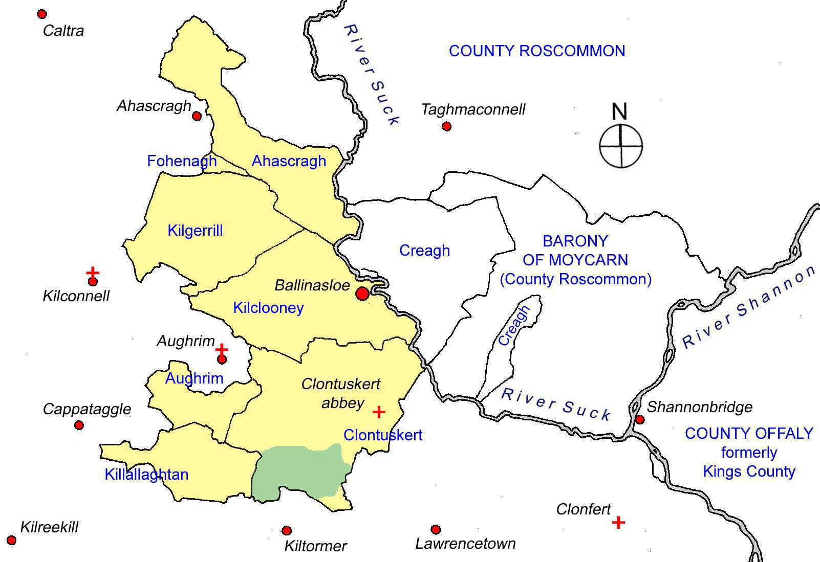
Map of the half barony of Clonmacnowen (in yellow) showing the approximate location of ‘The Bylle’ (in green) in the parish of Clontuskert, in relation to ecclesiastical centres and modern towns and villages (in red).
The Elizabethan soldier and settler Captain Anthony Brabazon of Ballinasloe acquired two quarters of the town and lands of Byllowes, in addition to lands at Trustan in Clontuskert prior to his death in 1597.[xi] The remaining two quarters of Byllies were held, for the most part, by various members of the O Dolan family. At an inquisition post mortem, taken in 1604 into the extent of the property of the deceased Anthony Brabazon, a number of individuals were at that time claiming lands held by Brabazon, including one Bryan O Dolan and one Edmundus oge O Dolan. The latter individual was in all likelihood the same man as that Edward oge O Dollan of the Bylle, gentleman, listed among the many recipients of a pardon from the Crown in the second year of the reign of King James I. It is possible that the lands disputed by Edmundus oge O Dolan were those in Byllies or Trustan in Clontuskert. It would appear that, if the land in Byllies was among the disputed property, the claimant or claimants were unsuccessful, as Brabazon’s son and heir, Malby Brabazon, would be found to hold the two quarters called ‘the premises of Byllis and Parke’ in an inquisition of 1627 and to have transferred the same to John Donnellan for £200 on condition of redemption.[xii]
The area of land known as the Bylle, Byllowes or Billies may be identified from a combination of various records. With the exception of his lands at Tristaun, Brabazon’s two other quarters of lands in Clontuskert in the mid seventeenth century were given as the half quarter of Ardrenny, the half quarter of Carrowcule and the quarter of Ballendolohan. These three denominations may be taken to comprise the two quarters of the Bylle that he acquired and half of the overall extent of the Bylle. As one Mulrone or Mulroony O Dolan held lands in Billies and Crossconnell in the early decades of the same century and his lands were given later as lying in Crossconnell, Carrowmore and Carrowculebeg, it would appear that both the quarter of Carrowmore and the half quarter of Carrowculebegg were part of the remaining two quarters.[xiii]
The Bylle therefore appears to have comprised a large tract of land across the southern end of that part of Clontuskert parish in the barony of Clonmacnowen. It extended east from about the modern townlands of Ardranny Beg and More to Carrowmore and Atticoffey, bordering Crossconnell and including the modern denomination of Newtownkelly. The Bylle in all likelihood included the modern townland of Gorteenaveela, lying between Lisheennavannoge and Carrowmore. Given the geographical location of the small townlands of Garrylawrence, Loughaunbrean, Ballynew, Taylorstown (and possibly Loughturk) lying between Ardranny, Atticoffey and Sheepwalk it is likely that these also formed part of the Bylle.
It is also possible that the large modern townlands of Ballagh East and West may have formed part of the Bylle. The origin of ‘Bylle’ as a place-name is likely to have been derived from the Irish noun ‘bile,’ an ancient tree, often originally of some sacred pagan significance. This ‘bile’ would appear to be the origin also for the denomination ‘Gorteenaveela’, ‘the small tilled field of the bile or sacred tree’ and is likely to be the origin also of the townland name ‘Ballagh.’ (The presence of a field within the modern townland of Ballagh East known locally as ‘Cloonaveela,’ translating as ‘the meadow of the bile’ would further suggest a close association between ‘Ballagh’ and the earlier ‘Bylle.’)[xiv] While Thomas O Kelly held the castle of Bealagh or Ballagh in Clontuskert in the early seventeenth century, he only held a small portion of Ballagh alongside the castle.[xv] The remainder may possibly be accounted for in the lands of the O Dolans.
The modern townland of Glenaun, adjacent to Crossconnell was also part of the Bylle as it was included as part of the lands therein possessed by fferall O Dolane, who died in 1612. His property at the time of his death comprised one quarter and a half cartron of land of Bylle or ‘Billowes’. Those lands were formed of parcels of land in the denominations of Gortnamona, Gortanarane, Knockanantanbally, Carrowmore et Cloghanantoodirry, part of Crosconnell called garroward and part of Crosconnell called Goramarly, Glenane, Lysnamoe, Lysnabranke (recte: Lisnafrankagh) and Carrowkylbege. The inquisition taken into the extent of his property in 1620 found that his heir was his son Terlagh O Dolane, who was married and of full age at the time of the inquisition.[xvi]
Landholders in the early seventeenth century
Almost all of the O Dolans who were confirmed in possession of their lands by the Crown in 1618 were resident at ‘the Bylle’ or ‘Billies’ and, like the majority of landholders recorded at that time in the same records, were described as gentlemen.
Tirlagh and Ferrall O Dollan of Billies jointly held one and a half cartrons of Billies and a half cartron of Crossconnell in Clontuskert. It would appear to be the same two men who also jointly held, together with Phelim and Morogh O Dollan of Billies, another cartron of Billies. Similarly, Brian, Donell and Thomas O Dollan of Billies jointly held three quarters of ‘Lisnarrow, parcel of the four quarters of Billies.’ Individually, John Dollan of Billies held two cartrons of Billies, Teige Dollan of Billies held a cartron of the same name. One Mulrone O Dollan of Billies held a carton of Billies and a half cartron of Crossconnell jointly with the large landowner Thomas O Kelly of Clontuskert, while Phelim O Dollan of Billies held a cartron of Crossconnell and two thirds of a cartron of Gortcharne in his own capacity.[xvii]
Teige O Dolane, with his wife Benvan nyn William of Meakny jointly held one sixth of a quarter of Meakny alongside a number of members of the O Kelly family at that same time.[xviii] (This Meakny is the modern townland of Mackney on the border of the parishes of Clontuskert and Kilclooney)
Landholders in the late 1630s
In the late 1630s the only O Dolans listed as significant landed proprietors in east Galway were Malrowy (ie. Mulroony) and John oge O Dolan. Malrowny possessed small portions of land in the denominations of Carrowmore, Carrowculebeg and Crossconnell in the parish of Clontuskert, while further to the south and in the adjacent barony of Longford, John oge O Dolean held lands in the parish of Kilmalinoge, in the quarter of that name and in the townlands of Fowermore and Gortgillmurrine, Gortrea, Cappaghbeg and Corr. In each townland he held his lands alongside Erevan mc Erevan O Cormican.[xix] It is possible, however, that this O Dolan only acquired these Kilmalinoge lands or a large part of the same in the early to mid seventeenth century as the lands in the latter two townlands he had acquired between 1618 and the late 1630s, having previously been property held by the O Cormicans.
Cromwellian Period
The O Dolans lost possession of their lands in this area as a result of the Cromwellian confiscations and transplantations in the mid seventeenth century. Much of the lands of Killmalinoge were reserved for Henry, son of Oliver Cromwell, as part of a large estate along the Shannon including the Earl of Clanricarde’s seat at Portumna, resulting in the confiscation of John oge O Dolan’s lands as part of that estate. Likewise the Dolans in Clontuskert lost ownership of their lands in the changes. Edmund Dolan in 1656 was ordered to transplant by the Cromwellians from Crossconnell and allocated 19 profitable Irish acres elsewhere within the same parish of Clontuskert. One John Dolan was likewise ordered to transplant, from Carrowmore in Clontuskert to the parish of Killallaghton, where he was allocated 14 profitable Irish acres.[xx]
Following the turmoil of that period and the restoration of the monarchy in the person of King Charles II in 1660, an Act of Settlement was passed in Parliament, in an attempt to address the complaints of those whose lands had been taken or divided by the Cromwellians and to placate those who had acquired lands at that time. The O Dolan lands in Clontuskert, in their possession in the late 1630s, were confirmed in the possession of others. While no mention was made of any lands confirmed upon Edmund Dolan under the Acts of Settlement, John Dolan was confirmed in possession of his fourteen profitable Irish acres in the parish of Killallaghton but records give the land as located within the townland of Cloneeke and formerly the property of various O Kellys prior to the Cromwellian period.[xxi]
[i] Twemlow, J.A., (ed.) Calendar of Papal Registers relating to Great Britain and Ireland, Vol. 14: 1484-1492, London, (1960), Vatican Regesta 700: 1484-5, pp. 62-9.
[ii] Vatican Regesta, Vol. DCCXIX. Bullarum Liber XXII. 3 Innocent VIII.
[iii] Calendar of Fiants Queen Elizabeth I, The thirteenth Report of the Deputy Keeper of the Public Records in Ireland, 12 March 1881, Dublin, A. Thom & Co., 1881, Appendix, Fiants, Eliz. I, No. 3718, p. 139. ‘Pardon to Redmund Bourke mcUllyck of Clontoiskirt, Co. Galway, gent., Redmund Bourk, son of Rowland of Tynaight, said Co., gent. Anable ny Vadden, wife of said Redm. McUllyck’ and others. 12 July xxiii; The Irish Fiants of the Tudor Sovereigns during the Reigns of Henry VIII, Edward VI, Philip and Mary and Elizabeth I, Vol. 2, 1558-1585, Dublin, Edmund Burke Publisher, 1994, pp. 660-1. No. 4608.
[iv] Cal. Pat. 1 James I, p. 18, p.28.
[v] Cal. Pat 2 James I
[vi] Calendar of Patent Rolls of Chancery of Ireland, 7 James I, p. 162. (Given elsewhere as ‘one cartron vocat’ Cartronlissenefrank in Carrowvornemly in Co. Gallway, pcell’ possession’ Maher’ O Dolean nup de Byllys attinct.’ Inquisitonum in Officio Rotulorum Cancellariae Hiberniae asservatorum Repertorium, Vol. I, Dublin, G. & J. Grierson and M. Keene, 1826, (Leinster), Inquisitions King Charles I, p. 12)
[vii] Described as ‘the four quarters of Billies’ in the Calendar of Patent Rolls of the reign of King James I, p. 417.
[viii] Cal. Pat. 16 James I, p. 417-8. Feriagh and Dermitt McShane O Kelly of Crossconnell held a cartron of Crossconnell and a half cartron of ‘Aticohy, parcel of the four quarters of Billies.’
[ix] Ellis, E., Beryl Eustace, P., Registry of Deeds, Dublin, Abstract of Wills, Vol. III, 1785-1832, Dublin, Stationary Office for the I.M.C., 1984, pp. 368-9.
[x] Cal. Pat. Rolls 16 James I, p. 417. As Atticoffey West is divided in two and separated by the modern townland of Newtownkelly, it is possible that Newtownkelly may once have formed part of Atticoffey also.
[xi] Egan, Rev. P.K., The Parish of Ballinasloe, its history from the earliest times to the present century, Clonmore & Reynolds, Dublin, 1960, pp. 304-5. Exchequer Inquisition post mortem into lands of Anthony Brabazon, dated 7th November 1604.
[xii] Egan, Rev. P. K., The Parish of Ballinasloe, its history from the earliest times to the present century, Clonmore & Reynolds, Dublin, 1960, p. 305. Chancery Inquisition taken at Loughrea, 8 October 1627 before Henry Bringhurst and others. Byllis and Parke in this inquisition are identified as one denomination, as both ‘Byllies and Parke 2 quarters’ and as ‘the premises called Byllis and Parke’, which suggests that they were the same denomination of land or at least adjacent to one another.
[xiii] MacGiolla Choille, B. (ed.), Books of Survey and Distribution, Vol. III, County of Galway, Dublin, Stationary Office for the I.M.C., 1962, pp. 126-8, Parish of Clonetoskert, barony of Cloone Mc Nowne. Several of the seventeenth century denominations did not retain the same name into the nineteenth century and several modern townland names do not appear as such in all seventeenth century records. Atticoffey is mentioned as part of Billies in the early part of the seventeenth century but does not appear in the same century’s ‘Books of Survey and Distribution.’ It therefore would appear to have been included in one of the above denominations relating to the Bylle.
[xiv] Clontuskert Heritage Group, ‘The Parish of Clontuskert, Glimpses into its past’, ed. by J. Molloy, Ballinasloe, 2009, p. 483. The Placenames Database of Ireland translates Ballagh in this case as ‘bealach’, ‘a way’ or’ path’ and Gorteenaveela as ‘goirtín an mhíle’, ‘the small field of the mile,’ both of which are unlikely meanings in these cases.
[xv] John Kelly of Bealagh in the half barony of Clonmcnowen held the castle of Bealagh, with one cartron of Killevin otherwise Bealagh, a half cartron of Lissnadrissa and half carton of Lisnafernoge, all in the same half barony. (Cal. Pat. Rolls 16 Jas. I, p. 417-8.) The castle lay in the modern townland of Ballagh West, while a small hamlet or cluster of houses lay in Ballagh East in the mid nineteenth century.
[xvi] National Archives, Dublin, R.C.4/14 Repertories of Inquisitions (Chancery), Vol. 14, Counties Galway and Leitrim, Eliz.–Wm. III, p. 337.
[xvii] Cal. Pat. Rolls 16 Jas. I, p. 417-8.
[xviii] Cal. Pat. Rolls 16 Jas. I, p. 417.
[xix] MacGiolla Choille, B. (ed.), Books of Survey and Distribution, Vol. III, County of Galway, Dublin, Stationary Office for the I.M.C., 1962, pp. 180-1.
[xx] Simington, R.C., The Transplantation to Connacht 1654-58, Shannon, Irish University Press, for the I.M.C., 1970, p. 95.
[xxi] MacGiolla Choille, B. (ed.), Books of Survey and Distribution, Vol. III, County of Galway, Dublin, Stationary Office for the I.M.C., 1962, p. 122.