© Donal G. Burke 2017
At some point prior to the mid sixteenth century a fortified structure was erected on a small island called Illanedarragh or Oileán na darach, opposite the townland of Keeloge in the parish of Meelick, to guard the narrow pass on the river immediately north of Meelick castle. The name of the island in the Gaelic language, translating as ‘island of the oak’, would suggest that it derived its name from an oak wood once flourishing thereon or an oak tree of note. The Shannon could be crossed at this pass by way of shallow waters between the eastern River bank and the large island of Incherky. From there the western bank at Keeloge could be reached by way of Illanedarragh. Still standing in the late seventeenth century, no part of this castle would remain by the mid nineteenth century. The island later came to be known as Old Castle Island and it also would later disappear as a result of works undertaken locally to the River Shannon.
The fording area between the ‘rough foorde of Milick’ and Banagher was described by the settler Matthew de Renzy in a latter to the Lord Deputy about 1620 as ‘next to (the ford at Meelick) is the passadge of Aheirce and Anascairve, twoo foords and an iland upon the Shennen betixt the twoo foords, wich iland doth for some part belong to my lord of Clanricard and for the rest belongeth to some of the Maddins, natives of that place. It is so strong, by reason of the Sheenen watter compasing it, as at cost not excessive it might be made in a manner invincible. Thereabouts is great abundance of stone to laye, lymeston, wood to burne lime, and timber for to build. The ways leading too and from this Milick and Aheirce be not tto good and therefore this place not so fitt to be made to a towne; it is ynough if it maie be fortified in time of neede, etc.’[i]
De Renzy did not make any specific reference to the existence of a castle at the river passage between Meelick and Banagher. The Aheirce referred to by de Renzy, however, appears to be a reference to the modern island of Incherky adjacent to Old Castle Island, the initial part of the placename a likely Anglicisation of the Gaelic ‘áth’ or ‘ford.’ The exact position of ‘Anascairve’ is uncertain. The Earl of Clanricarde did own most of Incherky alongside a number of O Maddens in the late 1630s.[ii]
It was found in the mid nineteenth century that the material which composed the shoal that formed the shallow pass at Keeloge ‘consisted of clay mixed with gravel, forming a conglomerate so compact that it was found necessary to use gunpowder to break it up’ during navigation improvement works at that time.[iii] As the northern tip of the small island upon which the castle was constructed lay upon the shoal, it is likely that the island itself lay upon a base as dense as the shoal and provided a solid foundation to the building. The strong current active on either side of the pass or the narrowness of the pass itself, however, may not have facilitated the easy transporting of building material onto the island.
The first reference to a building here occurs in July of 1557, when the Lord Deputy and his troops moved on the territory of the O Maddens in an attempt to dislodge rebellious O Connors who had found succour there. On his arrival at Meelick by way of Lusmagh, the Lord Deputy rode by the castle of Meelick, where the rebels were holding out, and being fired upon, made for his camp on the east bank of the river. In doing so he rode by the minor river pass north of Meelick castle and as he did so, ‘they of the castle that stood within the river likewise shot two or three pieces’ at the English contingent. That the structure was described as a castle at this time and in all subsequent references would appear to suggest that it may have been a tower house, a type of stone fortified castellated residence, in which the rooms were arranged in a compact manner vertically, most of which surviving locally appear to have been at least four stories in height. The castle on Illanedarragh would appear to have been constructed primarily for defensive purposes rather than economic, given its strategic location and the periodic flooding of the river islands in the vicinity. The castle appears to have been a small structure, in all likelihood significantly smaller than the nearby castles of Meelick or Cloghan and may have been closer in size to the not distant tower house at Brackloon, whose occupants were similarly engaged in supporting the rebels in concert with those of Meelick. Evidence of its small size may be taken from its description by the Athlone Pursuivant, who accompanied the Lord Deputy on his assault on Meelick at this time and who stated that on the arrival of cannon to support the Lord Deputy at Meelick, ‘they of the little castle on the Sennon set fire on their castle, and went to the castle of Mulbicke’.
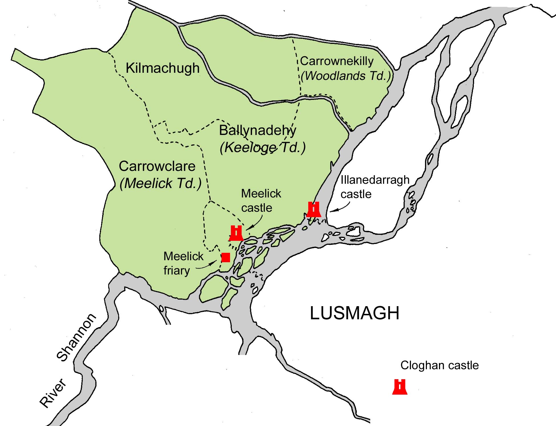
The approximate extent of the Manor of Meelick in the early seventeenth century, showing the location of the castle of Illanedarragh.
Illandedarragh was not included in a list of castles of O Madden’s territory or the Barony of Longford believed to date from about 1574 but an account of the Lord Justice Sir William Pelham’s journey on the River Shannon from late 1580 makes reference to Illanedarragh but not by name. On the 29th of August the Lord Justice boarded a boat at Killaloe and travelling upriver stopped later that day at Meelick. The recorder described Meelick as ‘an old ruined castle of her Majesty’s in an island, overthrown by the Earl of Clancare’s sons (recte: Clanricarde’s sons) where is a stiff ford hard to be passed against the stream, upon which ford O Madden hath a castle.’ (Edwards, D. (ed.) Campaign Journals of the Elizabethan Irish Wars, Dublin, Irish Manuscripts Commission, 2014, p. 109.) It is clear from other sources that O Madden to whom reference is made in this case is Owen balbh O Madden of Lusmagh, son of the former chieftain Melaghlin balbh and the castle upon the ford is evidently Illanedarragh. In the 1574 list of castles Owen O Madden is described as controlling both Cloghan castle in Lusmagh and Brackloon.
The manor of Meelick encompassed approximately four quarters of land about the principal castle of Meelick. Once the Crown regained initial intermittent control of that area within the mid sixteenth century the manor was defined as Crown lands which came to be leased to those regarded as loyal or of strategic use to the Crown. It is unclear whether Illanedarragh formed part of the manor of Meelick in the late sixteenth century but it is clearly given as such in one early seventeenth century reference. In December of 1570 the Queen granted to Richard, 2nd Earl of Clanricarde and his son John Burke a twenty-one year lease of the castle of Meelick. The property attached to the principal castle of Meelick was at that time described as the castle itself ‘on Yellow Island in the Shannon, comprising 1 stang of land, a ruined castle, a large hall, another ruined castle or gatehouse, another small island, the town of Mylleck comprising 6 cottages, 12 acres arable and 60 acres wood, underwood, more and pasture, another island in the Shannon, the greater of the said 2 islands containing 30 acres and the lesser 10 acres and 3 eel weirs on the Shannon.’ The Clanricarde’s lease was declared forfeit by Michaelmas 1576 when rent had not been paid thereon over that period. (Cal. Inquis. Eliz. 111a) No specific mention was made to the castle of Illanedarragh in the grant of 1570 and neither was there any named mention of Illanedarragh in 1577 when the Queen granted ‘the castle or manor of Mileeke on the Yellow Iland’ to one John Vawse, gent.’ The property was again said to contain 1 stang of land and the ruins of another castle, with a hall & another castle over the gateway within the precincts of the said castle.’ Vawse was accused of defaulting on the preceding half years rent in Easter of 1584 and his lease was in turn declared void later that year. (Cal. Inquis. Eliz 161/102) It may be expected that the large hall served as a communal building likely erected within the bawn wall of the principal castle. The reference to a castle over the gateway would appear to simply have been a fortified gatehouse controlling access to the same bawn. The question remains as to whether the ‘ruins of another castle’ mentioned in 1577 appear to be the same ruined castle mentioned in the 1570 lease. It is likely to be the same building given that the two descriptions of the manor are similar and the order of the buildings appear to be the same. The question then arises if the ruins of this second castle fell within the boundary of the principal castle itself as opposed to being a castle located on another island such as Illanedarragh. The manor came back into the hands of the Clanricardes once again with Richard Burke, 4th Earl of Clanricarde, confirmed as holding the Manor of Meelick in the early seventeenth century. The description of the manor was again similar to the earlier 1570s description, comprising as it did ‘the manor or castle of Meeleeke or Mylock in the Yallowe island upon the Shannon, containing one stang of land; to hold four quarters in Meelicke, free from Composition rent – another castle in Meeleeke – a hall, and another castle – another island adjoining to the Yallowe island – a small village near Mileeke, and six cottages, 120 arable, six acres wood, bog and pasture – two islands on the Shannon, the greater containing 30 acres of boggy pasture and the lesser 10 acres – three weirs upon the Shannon, and all other hereditaments of said manor, rent, 3l 6s 8d.’ It is still unclear if any of those three castles mentioned then was Illanedarragh but it is likely the third-mentioned castle was the gatehouse and the second the earlier previously-mentioned ruined castle. It cannot be stated with certainty that this ruined castle was Illanedarragh but it is unlikely that the boundaries of the manor altered over that short space of time and it is clear that in the early sixteenth century Illanedarragh was definitely included within the Crown’s manor of Meelick. This may be seen from another contemporary account of the Manor which simply gives it as ‘the manor and ruinous castles of Milick in the river of Shanen (with four quarters) the castle of Illanedarragh in Mylick with certain islands in the said river, belonging to Mylick, of which Manor of Milicke all the lands are holden by knights service.’
It is unclear if the castle was in good repair in either 1580 or in the early seventeenth century, but it was still standing in the late seventeenth century, at which time Captain John Stevens, an English Jacobite officer in the regiment of the Grand Prior, recorded in his journal on arrival at Meelick in June of 1691 that the place consisted ‘of a few scattering cottages, one gentleman’s house in an island and an old castle in another little island, upon one of the passes of the Shannon, which pass is convenient enough for travellers with a guide; but not for an army, the ford being narrow with several windings and dangerous on both sides.’ (The rapidity of the current at the pass at Keeloge was noted at the time of navigation works locally in the mid nineteenth century.)[iv] From the description of the pass, the old castle to which Stevens referred was evidently that on Illanedarragh.
The castle appears on a map of the estate of John Burke Colonel Lord Bophin, later ninth Earl of Clanricarde, dating from the late seventeenth century or early eighteenth century and on the same map, further south, a substantial house is also indicated, as opposed to a castle, on another Shannon island to the north east of the friary.
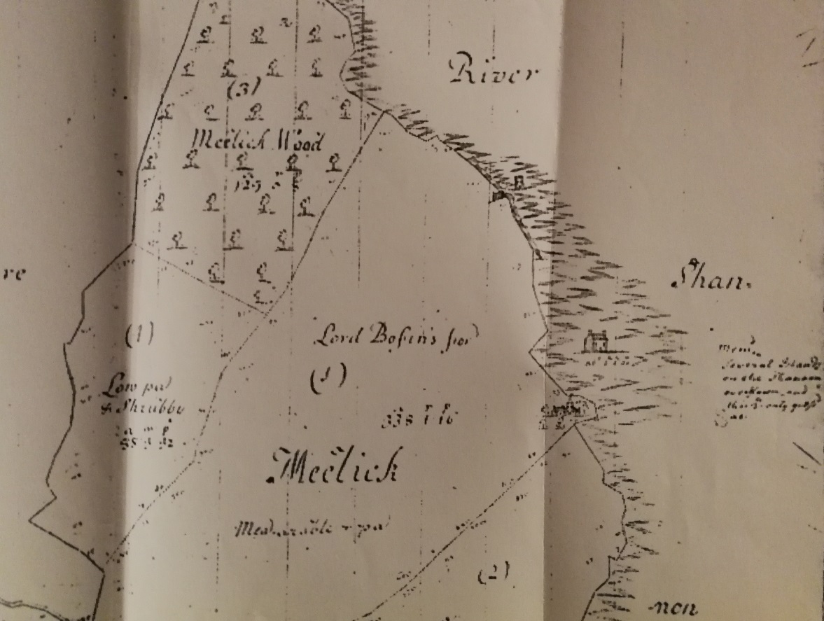
Illanedarragh castle, shown as a small castle within the River Shannon in Col. Lord Bophin’s estate map of Meelick. (c) NLI, Dublin.
There was no trace of the castle nor standing remains of any castle at Meelick remaining by 1838, at which time the parish and surrounding area was surveyed by Ordnance Survey researchers. The local inhabitants did, however, point to the previous existence of a castle called ‘Caisleán na darach’ or the ‘castle of the oak’ on Old Castle Island, the name derived, it would appear, from the earlier Gaelic name of the island.
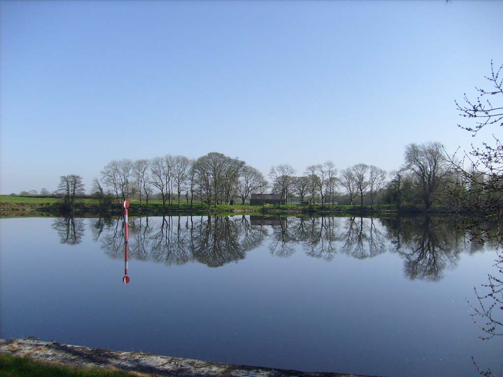
Old Castle Island and the route of its pass was indicated on the map produced in 1837 for the Shannon Commissioners in relation to a proposed weir and canal nearby and and again in 1842 on Ordnance Survey maps of Ireland of that year. On that latter map the island was described as containing only thirty five perches, but the island itself was no longer in existence by the 1890s and did not appear on the revised 25 inch maps dating from that period.

Map dated 1837 of the shoal at Meelick produced as part of the Second Report for the Shannon Commissioners, relating to the proposed weir and canal nearby, with Old Castle Island (indicated in red) shown but not named. No structure was shown on the island.
In Spring of 1842 works commenced to improve navigation on the Shannon about the old pass at Keeloge and were completed about 1846.[v] In addition to a large lock and a stone weir to regulate the discharge and the level of water, the river was to be deepened at Keeloge ford, ‘by excavating the bed to a depth of six feet below the present (pre-1844 depth) bottom, so as to give a depth of full seven feet six inches for navigation’ on the completion of the works.[vi]
In deepening the ford in 1842, ‘the contractors dammed off a portion of the river 100 feet in width and 700 feet in length’ and commenced an excavation nearly six feet in depth. The dams in question were formed on the Galway side of the river ‘for laying dry a considerable portion of the bed of the river. The material excavated was removed, partly to the adjacent bank and partly behind the western abutment of Meelick weir, being a length of about 500 yards; subsequently a breach was made in the dams to allow the water to pass through the newly excavated channel. A similar operation was then commenced on the King’s County side of the river.’[vii] The material excavated ‘consisted at the top of two feet of gravel, loose stone, and sand, and at the bottom of four feet of a mass composed of clay and rolled limestone, which in some parts was found so solid and compact that it became necessary to blast it with gunpowder in preference to excavating.’[viii] It would appear to have been as a result of these works that Illanedarragh, together with the ford and a number of small nearby islands, disappeared from view and any visible physical evidence of its previous existence lost in the expanse of the River Shannon between Keeloge and the broad island of Incherky.
Additional works were later required to the river, it being found that the 1840s works were insufficient and were partly attributable as the cause of extensive localised flooding, without having sufficiently improved navigation.
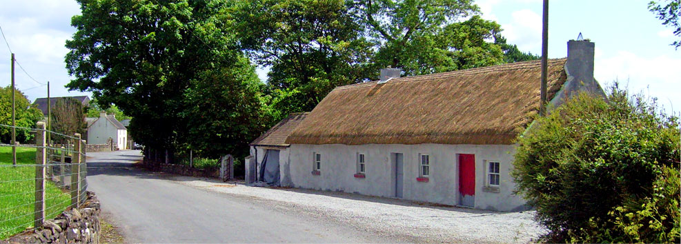
The last section of the former narrow river crossing between Leinster and Connacht wound its way across the Shannon from the island of Incherky to the riverbank in the Meelick townland of Keeloge. This last element of the crossing began in front of this cottage on Incherky (in the centre of this photograph) and travelled in a ‘zig zag’ route across the river to the Keeloge riverbank (in the foreground) by way of Old Castle Island. The disappeared Old Castle Island or Illanedarragh once lay in the middle of the river to the right and immediately outside of this photograph
[i] MacCuarta, B. and de Renzy, M., Mathew de Renzy’s Letters on Irish Affairs 1613-1620, Analecta Hibernica No. 34, IMC, (1987), pp. 177-178.
[ii] MacGiolla Choille, B. (ed.), Books of Survey and Distribution, Vol. III, County of Galway, Dublin, Stationary Office for the I.M.C., 1962, p. 189.
[iii] ‘Fourth Annual Report of the Commissioners for the Improvement of the navigation of the River Shannon, Ireland, with an appendix’, Fourth Report of the Deputy Keeper of the Public Records, February 28, 1843, presented to both Houses of Parliament, by command of Her Majesty, London, William Clowes & sons (for Her majesty’s Stationary Office), 1843, p. 9.
[iv] ‘On a collection of antiquities presented by the Shannon Commissioners to the Museum of the Academy, by Richard Griffith, Esq.’, Proceedings of the Royal Irish Academy, Vol. II, Dublin, M.H. Gill, 1844, p. 315.
[v] ‘Fourth Annual Report of the Commissioners for the Improvement of the navigation of the River Shannon, Ireland, with an appendix’, Reports from Commissioners; Ireland; Drainage, Ecclesiastical Commission, Education, Fisheries, Vol. XVIII, 1843, p. 167.
[vi] ‘On a collection of antiquities presented by the Shannon Commissioners to the Museum of the Academy, by Richard Griffith, Esq.’, Proceedings of the Royal Irish Academy, Vol. II, Dublin, M.H. Gill, 1844, p. 312-313.
[vii] ‘Fourth Annual Report of the Commissioners for the Improvement of the navigation of the River Shannon, Ireland, with an appendix’, Reports from Commissioners; Ireland; Drainage, Ecclesiastical Commission, Education, Fisheries, Vol. XVIII, 1843, p. 167.
[viii] ‘On a collection of antiquities presented by the Shannon Commissioners to the Museum of the Academy, by Richard Griffith, Esq.’, Proceedings of the Royal Irish Academy, Vol. II, Dublin, M.H. Gill, 1844, p. 312-313.